Balochistan
Pakistan’s largest province Balochistan with an area of 3,42,505 square kilometres is perhaps also the most striking. Mostly desert with rugged hills and rocky mountains, the province also has fertile valleys having rich orchards and prosperous farms growing apples, grapes, peaches and apricots in abundance. Baluchistan also has a fairly well-developed poultry and dairy industry.
Baluchis, as the people inhabiting this land are called, are proud, robust and fiercely independent. They harbour no domination and the British who came here in the late nineteenth century learned to respect and honour.
Balochistan is said to have a large reservoir of mineral wealth. Coal and gas produced here are used by the rest of hte country.
Given the promising mineral potential that this province has, Balochistan despite its vast deserts and present wilderness may well prove to be a reserve bank for the future development of Pakistan. Fishing is the principal occupation and source of income for the coastal towns of Gwadar, Turbat and Pasni all of which are already well linked by frequent and scheduled PIA services.
Quetta, the provincial Capital is the only city having a fairly dominant urban population. Until the British arrived in 1877, Quetta was little more than a fort and a small training post. The British army led by Sir Robert Sandman was charged with the responsibility of keeping the road link between the then India and Afghanistan via Balochistan open. Equally important was the responsibility to keep open the Bolan Pass connecting Balochistan with Sind. The British army, therefore, made Quetta a military centre from where to operate against the Balochis unwilling to accept foreign subjugation.
Quetta, is located 5,550 feet above sea level enjoying a healthy climate. The temperature drops a few degrees below the freezing point in winter following a typical autumn when the leaves turn golden and then a wild red.
Very few places can compete with Quetta valley in having wide range of tasteful fruits, exported to all parts of the country as well as abroad. There you can find plums, peaches, pomegranates, apricots, apples, olives, different types of melon, water-melon, cherries, pistachios, almonds and other dry fruits. Saffron and tulip are also grown and cultivated on a commercial scale. The fruits heaven is Urak, called SAMARISTAN meaning the land of fruits in Persian.
Excavations in the Quetta valley have proved that the pre-historic humans used to live there.
Mehergarh is a unique site revealing a continuous sequence of cultures in the Province. The archeological sites are considered to have been flourished between 7000 B.C & 800 B.C.
Modern day Quetta is a real growing centre of excellence. It is rapidly progressing in various walks of life.
A visit to this province will however, be incomplete without a trip to Ziarat, a hill town 8000 feet above sea-level Airconditioned coach and taxis take anything between an hour or two from Quetta an ideal and relaxing summer retreat with rows of juniper trees and ever green slopes.
The word Ziarat means holy place to be visited and the valley is known by that name because of a shrine of a holy saint, Tahir Baba Khirwari. There are other graves as well. However, the world knows it more because of the oldest and tallest juniper jungle, which needs to be looked after properly for future survival.
Extremely delicious species of apple, black cherry and almond trees are abundant in Ziarat, covering about 4416 acres in the lap of mountains.
While Ziarat abounds in tall chinar trees and juniper grows wild as does walnut and a variety of other trees, the area west of this hill station leading up to the Afghan border is rocky and barren. The drive through this unfriendly terrain provides one the grim reminder of the fierce tribes who roamed free in the region and kept the British weary and fearful. The border village of Chaman is also a major trading centre for a variety of fruit, a large quantity of which is still brought in from Afghanistan.
Lying at a height of 2713 meters above sea level and 6 km from Ziarat, the beautiful place provides fantastic view.
Bolan PassIf you have a passion for smelling history through places, you must visit the Bolan Pass, where several armies from Central Asia and north intruded into the lands of un-divided India through centuries. The picturesque hilly road welcomes you with cool breeze.
While cruising through the hilly tract between Quetta and Kalat, you would come to see the route to Zahidan, Iran. Koh-e-Taftan and Saindak copper mines are en-route.
Being the most arid province, the Balochistan receives very low rain fall. Natural springs, used for supplying water to other places have been very common. But for now, most of the springs are artificially made by boring holes into rocks. They are called ‘KAREZ’. There are more than a dozen gorges (Tangi in local language) around Ziarat, formed by Karez water.
There are 225 species of plants in Hazarganji Chiltan National Park, including wild almond, juniper, pistachio, wild olive and various useful shrubs.
Driving through wild roses and fruit orchards, you may reach the Urak Valley at a distance of 21 km. The abundance of delicious fruits make it a real fruit land or SAMARISTAN.
If you wish to enjoy excursion just near the city, you must go to Hanna Lake, 10 km from Quetta and very close to the Urak. The turquoise water of lake is a real contrast to the brownish green hills that surround the area.
Filled with numerous fruit orchards, the Pishin Valley is 50 km away from Quetta. These orchards are irrigated by ‘karez’. There is yet another attraction of cool waters, i.e. man-made lake with Bund Khushdil Khan. A wide range of ducks provides enticing beauty during winters.
The festivities include a colourful programme of folk dancing by thousands of participants from different regions. Horse jumping, trick horse riding, trick motor cycle riding, dare-devil motor car driving and a dog & hare race are among the highlights of the festival. The principal attraction of the show, however, remains the impressive display of the best available specimens of Pakistani livestock.
As the sun sets over the impressive Fortress Stadium, the venue of the show, fireworks display, military tattoos and brass band pageants enliven the evenings and enthrall the spectators.
During recent decades, a lot has been done to explore the culture and civilization of ancient people. The most distinguishing one is Mehergarh, which experts say remained the centre of high development some 9,900 years ago. Researchers claim that this was a civilized society of 7000 B.C that is even older than Moenjodaro and Harappa.
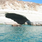
Balochistan shares the major part of Pakistan’s coastline, extending over 750 km from Hub near Karachi, to the Gwadar sea-port near Pakistan-Iran border. The variety of marine life, assure blue sea-water and sunny beaches provide breath-taking environment. Coastal towns of Pasni, Jiwani and Gwadar are now the centre of attraction for foreign and local investors. All are linked by air with Karachi. The people have a very colourful culture, displaying themselves briskly through their multi-colour dresses and ornaments.


No comments:
Post a Comment